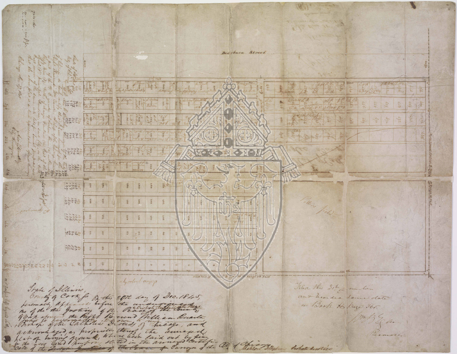
The plat covers the ground from Dearborn Street (written at top, middle on the fold), east one block to today's State Parkway. (In 1845 this was open land. State Parkway, first named Wolcott St. did not run through here until the cemetery grounds were converted to residential streets in the early 1880s.) The right edge of the map (north) is North Avenue. The left edge is today's Burton Place. The Catholic cemetery grounds later spread one block east to the lake (today's Astor Street) and one block south to today's Schiller Street.
The alleys which run north and south between the square numbered plots are five feet wide in the northwest section, and six feet wide in the south half. The cemetery plots are twenty-foot square. These plots are sometimes divided horizontally, sometimes vertically and less often segmented into four squares each 10'x10'. It appears that the oldest section of the graveyard is the area covering the corner of Dearborn St., running north for 280 feet from Burton Pl to North Avenue, then running east for 150 feet. The open quadrant on the northeast corner is labeled Potter's Field. (It is likely that this potter's field, with time, extended eastward, encompassing the grounds where the Cardinal Mansion remains today, since its construction in 1885.)
The entrance to the cemetery was on Dearborn Street, midway through the grounds, labeled Gateway on the plat.
The vault, which is the holding place of a body before its burial, is located at the northwest corner of the center intersection of the ten-foot wide main thoroughfares.
There is a diagonal line running northwest through the northwest quadrant of the map. This may mark a rift in the grounds or some other land feature that prevented its use for proper burials. There are no cemetery plots drawn from that point, extending into the potter's field
The three blocks of text are in the handwriting of brothers William and Mahlon Ogden, and the City Surveyor, Asa Bradley.
(According to records in the Chicago Title and Trust Archives, William Ogden annexed this land, which he owned, to the Catholic bishop. William Odgen was Chicago's first mayor in 1837. His brother Mahlon became known as the man whose home remained standing after the Chicago Fire of 1871.)
The text running vertically along the left edge reads:
State of Illinois, County of Cook. On this 29th day of Dec. 1845, personally appeared before the undersigned of the Justices of the Peace & Probate Justice of the Peace of the County of Cook aforesaid the Right Reverend William Quarter who is personally known to me, Bishop of the Catholic Diocese of Chicago, and acknowledged, as proprietor thereof, the annexed plat of burying ground, to have been laid out by him for the uses and purposes stated in the annexed certificate of the Surveyor of the City of Chicago. Mahlon D. Ogden, Probate Justice.
The blocks of text at the bottom of the plat reproduction read:
State of Illinois, City of Chicago
I, Asa F. Bradley, Surveyor of the City of Chicago, do hereby certify that I have surveyed for the Right Reverend, Wm Quarter, Bishop of the Chicago Diocese a part of the N.E. quarter of Section Four (4) in Township Thirty Nine (39) North of Range Fourteen (14) East of the Third (3d) principal Meridian, in said City, in the North East corner of the same, into lots for burial purposes and that the above plat is a true representation of said survey.
Chicago Dec. 27, 1845
Asa F. Bradley, City Surveyor
Filed the 30th December and recorded same date in Book H, Page 365.
Wm B. Ogden
|
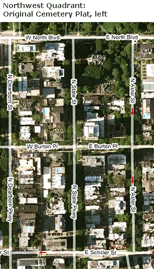
The Google EarthTM satellite map, above, shows
the entire area of the Catholic Cemetery. |